Victoria’s Geology
Victoria has a fascinating geology which has enabled the construction materials to thrive as an industry. Following is an investigation into the history of Victoria’s geology based on the information provided by GEOSCIENCES VICTORIA.
THE geological history of Victoria can be divided into three major episodes.
- Neoproterozoic to Early Carboniferous: development of the Delamerian and Lachlan Fold Belts involving cycles of marine and non-marine deposition alternating with deformation, intrusion of granites, volcanism and metamorphism. This consists of the Neoproterozoic to Ordovician period (520- 440 Ma); Silurian period (440 – 420 Ma),Devonian period (420 – 350 Ma); and early Carboniferous period (350 – 325 Ma);
- Late Carboniferous to Mid-Mesozoic: a period of apparent tectonic stability characterised by extensive erosion, which produced a landscape of low to gentle relief over most of south eastern Australia; and
- Mid-Mesozoic to the present day: Australia separated from Antarctica and New Zealand during the breakup of Gondwana. The main breakup occurred in the mid Cretaceous when the Tasman Sea began to open and Australia’s northward migration was initiated.
NEOPROTEROZOIC TO EARLY CARBONIFEROUS
This period is covered by the recent Geological Survey of Victoria publication ‘The Tasman Fold Belt System in Victoria’.
The sequence of events associated with the building of south eastern Australia reveals that mineralisation and magmatic processes are intimately linked with the tectonic development of the region. The history is dominated by east–west compression of predominantly oceanic sedimentary and volcanic rocks and their resultant folding, faulting and uplift .
Recently, it has become increasingly apparent that major north–south movements have also been involved in constructing eastern Australia.
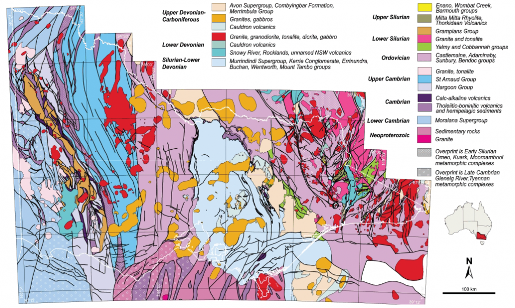
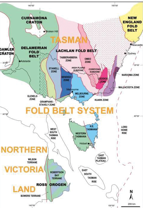
The Palaeozoic basement is traversed by thrust faults more or less parallel to the north–south structural grain. The largest faults separate rocks with different ages and structural histories, and subdivide Victoria into three main structural rankings consisting of two fold belts (Delamerian and Lachlan), two terranes in the Lachlan Fold Belt (Whitelaw and Benambra), and ten structural zones (Glenelg, Grampians–Stavely, Stawell, Bendigo, Melbourne, Tabberabbera, Omeo, Deddick, Kuark, Mallacoota).
The Moyston Fault is the most important fault as it forms the terrane boundary between the Delamerian and Lachlan fold belts. These two fold belts show important differences. The Delamerian Fold Belt is mainly composed of Neoproterozoic–Cambrian rocks and was deformed in the Late Cambrian Delamerian Orogeny whereas the Lachlan Fold Belt contains mainly Cambrian–Devonian rocks with main deformations occurring in the Late Ordovician–Early Carboniferous interval.
The first regional deformation to affect the Lachlan Fold Belt was the Benambran Orogeny, about 50 m.y. after the Delamerian Orogeny. Granites comprise 20% of the total exposed area of the Lachlan Fold Belt and fall within an age range of 440 to 350 Ma. Volcanics associated with the granites are also widespread and cover an additional 5%. Blocks of older crust consisting of Neoproterozoic–Cambrian rocks, such as the Selwyn Block in central Victoria, were deformed during the Late Cambrian Tyennan Orogeny prior to being incorporated into the Lachlan Fold Belt.

The second major structural break in Victoria is the Baragwanath Transform, which occurs along the eastern side of the Selwyn Block. This transform fault divides the Lachlan Fold Belt into two terranes, the Whitelaw Terrane to the west and the Benambra Terrane to theeast. The main difference between these is that orogen-parallel (north–south) transport was more prevalent in the Benambra Terrane, whereas convergent east–west transport orthogonal to the orogen was dominant in the Whitelaw Terrane.
LATE PALAEOZOIC AND MESOZOIC EPICRA TONIC SEDIMENTATION
Late Carboniferous to Early Permian (300-285? Ma): glaciation and marine sedimentation
At this time the Australian portion of Gondwana lay near the South Pole and had a glacial climate. Glacial deposits are widespread across southern Victoria, especially at Bacchus Marsh and east of Bendigo. They consist of tillite, slump deposits and sandstone and siltstone (WildDuck Formation and Boorhaman Conglomerate) deposited by glaciers and periglacial and sub-glacial streams, probably in a glaciomarine environment. Striated pavements show that ice movement was mainlytowards the north. Marine conglomerates occurring as far south as Bacchus Marsh suggest that a substantial part of the tillites may have been deposited in shallow marine conditions. The Urana Formation,occurring in the subsurface in north-central Victoria, is entirely marine, deposited in quiet, anoxic water.
Triassic (250-205 Ma): rivers and granites
Triassic rocks are of very limited distribution in Victoria. At Council Trench near Bacchus Marsh, a very thin cap of conglomerate, sandstone and mudstone with chopped-up plant fossils is a fluvial deposit. It overlies glaciomarine Permian sediments. In the Benambra region in Eastern Victoria, the Mount Leinster Igneous Complex is scattered over an area ofabout 350 km2. It is a suite of alkaline igneous rocks consisting of trachyte, volcaniclastics, volcanogenic sediments, syenites and porphyritic granites. The Teapot Creek Formation represents the remains of a once extensive sheet of volcanics which was deposited onto the Triassic land surface. This was subsequently intruded by a number of high level syenite and granite porphyry bodies. Apart from being within-plate intrusions, the tectonic setting of these rocks is poorly understood. Perhaps they herald the extension and subsequent breakup of Gondwana.
LATE JURASSIC TO THE PRESENT DAY
Late Jurassic to Cretaceous (ca. 150-65 Ma): breakup of Gondwana
The Gippsland, Bass and Otway basins form part of the Southern Rift System, which formed as a result of rifting and continental breakup of the Australian and Antarctic continents. During the late Jurassic – Early Cretaceous (150–120 Ma) early rift -fill lacustrine and fluvial sediment sand minor volcanics (Casterton Formation and Crayfish Group) were deposited in a series of half-grabens formed in the Otway, and possibly Bass, basins as part of the Gondwana breakup. Rifting and associated sag continued through to the end of the Albian (95 Ma) resulting in a thick, volcaniclastic-rich sequence of nonmarine greywackes, mudstones and minor coals (Eumeralla Formation and Strzelecki Group). Th ese fl uvialsuccessions are today exposed in several basement highs (Otway andStrzelecki ranges).
With the onset of sea-floor spreading between Australia andAntarctica during the Late Cretaceous Cenomanian, the terrestrial to marginal marine Sherbrook Group was deposited in the Otway Basin. This contrasts with the lacustrine rift -fill sediments of the Emperor and Golden Beach subgroups in the Gippsland Basin, associated with the development of the Tasman Sea rift during the Cenomanian to Early Campanian (95–80 Ma).
The Bass Basin persisted as a failed rift, with nonmarine sedimentation continuing until the Eocene (Eastern View Group).

At the basin margins, subsidence was balanced by major uplift of the coastal hinterland represented by the Great Dividing Range in Victoria. The area to the north east of the range was not uplifted, but became the Murray Basin and was filled with mainly marine sediments (Millewa Group).
Palaeocene to Recent (65 Ma-present day): paralic sedimentation, stream incision and basaltic volcanism
The Late Cretaceous uplift began a cycle of incision and lateral erosion that continues to the present day. Sediments eroded from the highlands were transported onto the wide coastal plain as well as further off shore.
The coastal plain environment of the Gippsland Basin included large swamps and marshes, parts of which were later converted into coal beds that are regarded as the main source rocks for the basin’s economic oil and gas accumulations. In the Latrobe Valley, the geological and climatic conditions from the Eocene to the Miocene were favourable for the generation of extremely thick brown-coal measures (Latrobe Group).
Marine clastic sedimentation continued in the Otway Basin (Wangerrip and Nirranda groups) until the Oligocene.
From the early Oligocene onwards, deposition of marine siliciclastic sediments ceased in the off shore and was followed firstly by the accumulation of fine-grained clay-rich, then by prominently fossiliferous cool-water carbonates. Nonmarine sedimentation prevailed in the Murray Basin, becoming marine in the Oligocene.
Episodes of tectonism have repeatedly modified the sedimentary pile of the southern basins into a complex structural system, reflecting the rift architecture of Victoria’s basins.
Within the last two million years small scale volcanic eruptions (Newer Volcanics) have had a major impact on the Victorian landscape. About 400 volcanoes have produced extensive basalt flows forming a thin veneer (generally less than 50m) covering much of western Victoria. The basalt plains consist of superimposed valley flows and volcanic centres with associated basaltic aprons.


You must be logged in to post a comment Login