Aerial Surveying for Quarries
ERIK BIRZULIS, Director of LANDAIR SURVEYS reports on the benefits of Aerial Surveying for Quarries.
THE changes to the features of a landscape tell a story that anyone can see, however, telling that story accurately requires experience and knowledge. Landair Surveys have been telling this story for over thirty years and their skills in taking and analysing aerial photography can play an important part of any quarry operation.
Aerial surveying provides a range of benefits particularly suited to projects covering large areas and subject to ongoing changes. A single flyover captures the layout of a entire site and provides a more economical way of surveying a large area than a traditional ground survey.

common quarry issues
Pretty photographs are not the only deliverable. Once aerial photographs are gathered, then plans and 3D models can be produced to help build an accurate picture of each site’s complexities.
The 3D model supports:
- Measurement of stockpile volumes for end of year auditing. Tonnage over conveyor belt scales minus tonnage of stockpiles should equal tonnage over weighbridge.
- Calculation of royalty volumes.
- Calculation of stripping material volumes.
- Assisting geologists to design new work plans for existing and new quarries.
- Preparing visual impact assessments and 3D flythroughs.
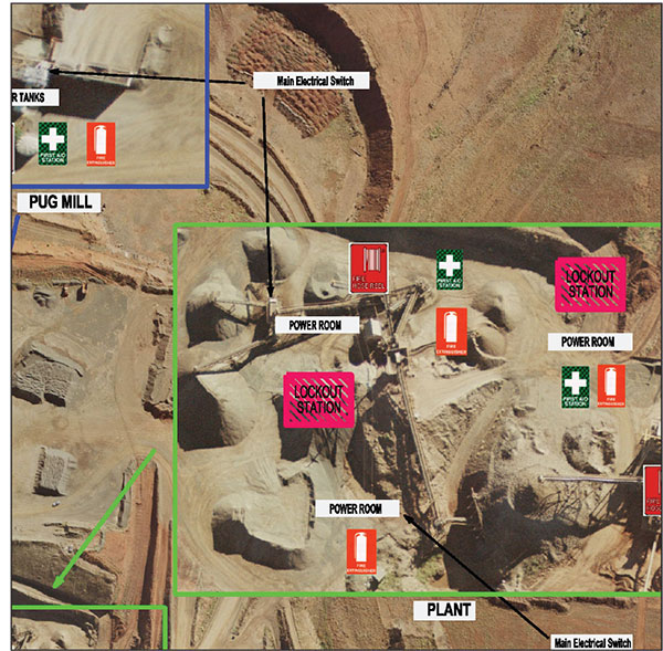
The aerial photograph can also be used as a background for:
- Traffic Management Plans,
- Site Safety Plans,
- Town planning requirements,
- Underground Services Plans, and
- Investor and stakeholder relations and more.
Landair Surveys has been assisting quarry owners and operators plan and manage their resources for over 30 years.
For further information please call Erik Birzulis on 03 9887 2888 or
email [email protected]


You must be logged in to post a comment Login