VALUING QUARRY RESOURCES
The value of a quarry is underpinned by its geology. ROD STEPHENS of Stephens Valuation & Consultancy Pty Ltd provides information on the factors that impact on the value of construction material resources.
IT is common to measure the extent of the geology by calculating the quantities of reserves and resources within the Work Authority, making allowances for construction material ownership, benches, set backs, roadways, easements and other constraints.
Once established and risk assessed, then the reserves and resources are valued by applying an annual output of the expected market sales tonnages times the market rate to produce an income, and then capitalised using the market capitalisation rate (suitably adjusted for the various risks) over the life of the resource to produce a capital value.
RESERVES AND RESOURCES
It is usual to split the reserves and resources into several broad categories namely Proved, Probable and Possible.
A typical reserves and resources summary would be set out as per Table 1 below.
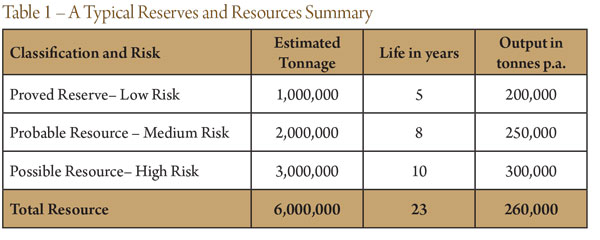
Proved Reserves – Low Risk.
These indicate a high level of certainty as to the quality and quantity of a resource.
Probable Resources – Medium Risk.
These would involve areas where very little geological testing has been done, although the likelihood of the resource existing is still very strong.
Possible Resources – High Risk.
These resources would either be resources outside of a consented area, or deposits at greater depths than borehole records.
For valuation purposes the proved, probable and possible reserves and resources are assessed to identify the different levels of risk and uncertainty involved in each category.
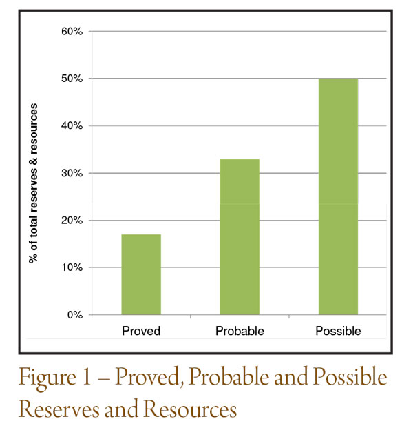
The risk factor should also be adjusted depending on the lifespan of each category and the stone/sand output (see Figure 1).
CALCULATION OF RESERVES AND RESOURCES
This involves the Site Area (consented) x Allowable Depth x Density to provide the total tonnage of a resource. Allowances are then made for quarry benches, construction material ownership, set backs, easements and many other factors and then categorized into proved, probable and possible.
LIFE OF THE RESOURCE
This can be calculated by dividing the total reserve or resource by the estimated annual output (see Figure 2).

GEOLOGY
Geological mapping is available for the majority of populated areas throughout Australia and provides a host of information.
In broad terms geological deposits are identified as Sedimentary, Igneous or Metamorphic, which are identified in cross section below.
Metamorphic rocks (e.g. hornfels) are either igneous or sedimentary rocks that have been altered by heat and pressure and are commonly formed in a halo around an igneous body.
Geological mapping provides a range of information such as the location of different aged rock types together with detailed descriptions of the rock types. The mapping also shows known and conjectural fault lines, dip of the strata, previous mines, overthrows, thrusts, synclines and anticlines and often cross sections through the stratum.
Faulting is important to identify as it may increase the overburden of a deposit, rendering the resource uneconomic due to the additional cost of extraction.
BOREHOLE INFORMATION FOR HARD ROCK
The extracted cores from a borehole, can provide an indication of the consistency of the resource at depth. For certain rocks, the quality at depth can be very different to the surface deposit, as oft en the deeper deposit has been subject to less weathering or compaction for possibly millions of years.
TRIAL PITS FOR SAND, GRAVEL OR CLAY
This involves excavating a large hole often to 3 to 4 metres in depth, and records can then be taken of the cross section of the hole in various directions, but also a large representative sample can be taken of the material excavated.
MATERIALS TESTING
There are a variety of tests that can be carried out on quarry products. The most common practice involves sieve testing where the different particle size fractions are determined. This needs to be carried out on a regular basis at most quarries.
For hard rock operations, jaw crushers can wear and alter the particle size produced over time, whilst for sand operations, the particle grading must be of particular size fractions if the sand is used within concrete.
HYDROLOGY & HYDROGEOLOGY
Any evidence of streams, rivers or springs within the quarry extraction area should be noted as well as the presence of any water tables derived from boreholes.
OVERBURDEN
The overburden from the quarry extraction area is often removed and stockpiled around the perimeter of the quarry extraction area and then utilised for future restoration. If overburden is significant then this can render the resource uneconomic.
HOW TO VALUE RESERVES AND RESOURCES
An economic reserve and resource is only worth the income that can be derived from it. There are many instances where operators think that the way to value the resource is to multiply the total resource tonnage of say 6 million tonnes by the market rate of say $2 per tonne to provide a figure of $12 million.
This is clearly wrong but is widely practiced and has no regard to the output or market demand or the speed at which the resource is worked or the risk involved within the market place.
A typical resource evaluation is as set out in part in Table 2 below.
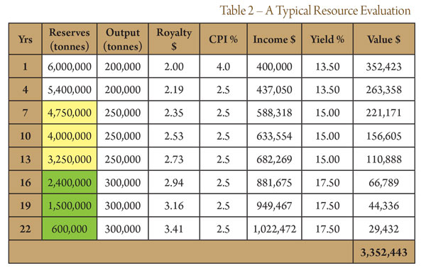
The table shows how the reserves and resources have been classified into Proved (Clear), Possible (Yellow) and Probable (Green), and risk assessed by increasing the yield to reflect the uncertainty throughout the life of the reserves and resources.
For more information contact Roderick Stephens on 0423 383 343 or email
[email protected]


You must be logged in to post a comment Login